Did You Know?
Scotland Map and Distance Table
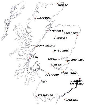
Planning a holiday in Scotland and wondering how long it will take to travel around Scotland? Even if you have a road map of Scotland, the mileage tables usually only quote a few places in Scotland. So here is a map with the locations of 15 cities and towns in Scotland - and a table showing the distances between all these places (plus a few in England). There are also some useful notes on estimated driving times.
Distance Chart (in Miles)
 63 63 | Aviemore |
| 216 | 223 | 92 | 94 | Carlisle |
| 157 | 60 | 196 | 141 | 211 | 131 | Fort William |
| 146 | 138 | 110 | 33 | 95 | 43 | 116 | Glasgow |
| 105 | 28 | 220 | 207 | 260 | 154 | 64 | 175 | Inverness |
| 543 | 528 | 342 | 386 | 307 | 404 | 509 | 402 | 569 | London |
| 179 | 108 | 186 | 124 | 192 | 121 | 48 | 96 | 112 | 498 | Oban |
| 84 | 81 | 111 | 95 | 132 | 45 | 106 | 62 | 117 | 423 | 92 | Perth |
| 93 | 55 | 137 | 120 | 167 | 69 | 75 | 83 | 85 | 473 | 91 | 26 | Pitlochry |
| 228 | 222 | 103 | 50 | 100 | 131 | 182 | 84 | 253 | 406 | 172 | 145 | 168 | Stranraer |
| 79 | 117 | 121 | 118 | 158 | 50 | 134 | 81 | 145 | 465 | 125 | 35 | 60 | 165 | St Andrews |
| 119 | 112 | 104 | 64 | 111 | 36 | 96 | 27 | 143 | 417 | 86 | 35 | 58 | 112 | 52 | Stirling |
| 211 | 139 | 330 | 312 | 359 | 261 | 174 | 275 | 109 | 665 | 222 | 219 | 192 | 360 | 252 | 250 | Thurso |
| 158 | 84 | 276 | 258 | 305 | 208 | 109 | 222 | 56 | 611 | 158 | 165 | 139 | 306 | 198 | 193 | 120 | Ullapool |
Notes on Distance Chart
- Distances are expressed in miles and have been calculated by road map software, selecting the shortest distance between each point.
- In order to make each cell in the chart the same size, an invisible graphic has been used where there are only two digits. You must have the graphics option switched "on" in your browser to avoid getting "broken graphic" icons throughout the table.
- To convert the distances to kilometres, multiply the mileage by 1.6.
Estimating Journey Times
- The speed limit on Motorways and dual carriageways in the UK is 70mph. However, in Scotland most of these trunk roads have only two lanes in each direction. Consequently, particularly at busy times, you are likely to achieve an average speed of only 60mph at best.
- There are motorways and dual carriageways linking Glasgow to Edinburgh, Glasgow to Perth, Glasgow to Ayr, Edinburgh to Perth and Perth to Aberdeen as well as from Glasgow and Edinburgh to England.
- The speed limit on roads which are not at least dual carriageway standard is 60mph. There are wide variations in the quality of these, ranging from the A9 from Perth to Inverness which has some stretches with dual carriageway to single track roads with passing places in the far north-west. Average speeds are therefore often around 40mph and even less on the poorer roads.
- You can find detailed road maps of Scotland (and the rest of the UK) at Streetmap UK and Multimap.
- There is a Gazetteer of Scottish towns and villages which has descriptions of many of the towns, villages and attractions around the country.
Use the "Back" button on your browser or click here to return to the Index of "Did You Know?"
Where else would you like to go in Scotland?


